Methodology
Methodology
Mission
It is our mission to propose a infrastructural development strategies for Monwabisi Park that will offer improvements to safety, lighting, storm-water runoff, roads, and housing organization. In collaboration with both external organizations and the residents of Monwabisi Park, we will propose possible redevelopment designs and create a three dimensional model of the park that can serve as a visual aid for redevelopment planning now and in the future.
Objectives
- Create a Monwabisi Park Urban Framework Redevelopment Strategy
- Create, in cooperation with other teams, a Redevelopment Seed proposal
- Investigate current pedestrian safety measures and propose improvements
- Propose improvements to path and street lighting
- Create a three dimensional model of C-Section of Monwabisi Park
- Create print and electronic maps for other WPI teams as necessary.
Process
The idea of creating an Urban Framework Proposal for Monwabisi Park arose from two sources: a need to combine all of our work and a previously made Urban Framework Proposal for Khayelitsha C&TR Sections (VPUU 2009). This Urban Framework was provided by our sponsor, the Violence Protection through Urban Upgrading, and served as a template for our own work, where we kept the formatting and the key topics, but changed the details and added new topics of interest relative to Monwabisi Park and our own research. Unfortunately, their original document is not currently available electronically. Inside our Framework, we placed all of our proposals (for new sidewalks, crosswalks, lighting, and roads) as well as much work previously done by the VPUU or other WPI IQP groups. The compilation of all this work can serve as a foundation for the VPUU to create a complete complete Framework that can be used to get city permission and funding to proceed with the redevelopment efforts.

Exploring the park
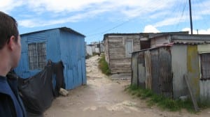
In making our suggestions, we first gained a basic knowledge of the area and existing conditions through firsthand experience by touring the park, interviewing residents, and taking pictures of key locations and elements in both C and M sections of the Park. We also extensively used previous work to familiarize ourselves with the area, most notably “Envisioning Indlovini” (WPI CTPC 2008) created by the 2008 students of WPI CTPC and the Baseline Survey of Monwabisi Park conducted by the VPUU in 2009. We discussed our options and focused on several key areas for improvements: storm water management, pedestrian safety, and formal roads. Our strategy in making proposals followed the same method for each of our final proposals.
We first researched the existing conditions through interviews with community members and co-researchers. The community members were largely drawn from either business owners (for the roads and urban planning surveys) or those affected by flooding for storm water management. In both cases, we found the persons to interview by walking through the Park and stopping in affected areas. Our co-researchers would point out affected houses, or businesses along Mew Way for us to talk to. Interview questions regarding flooding were informal and often created on the spot by a co-researcher. Questions for business owners were the following:
- Do you own this business?
- Do you live at the business?
- Do you need more living space? More business space? Which one is more important?
- Would you be willing to live on a second story above your business? Or do you like living on a second story above your business?
- What housing/business layout would you most like?
- How do you get goods/services not located in the Park?
- If you have your own car, where do you park it?

Storm Water Problems
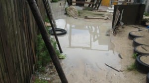
While traveling C and M sections, we took pictures of notable features, especially regarding storm water management and pedestrian travel inside the Park. All pictures were taken by a co-researcher. Storm water pictures were taken early afternoon after a morning rain in late spring for Cape Town. The rainy season is June and July (winter) and therefore it should be noted that any problems documented here will only be worse during that time.
In addition, we consulted several sources for their suggestions on the matter at hand, most notably Peter Inglis of Haw & Inglis, Professor Kevin Winter of University of Cape Town, and Michael Krause of the VPUU. Peter was especially helpful with urban planning and road development while Professor Winter was approached for help with GIS mapping and became invaluable with water management. Michael Krause was beneficial to the project all around as our sponsor liaison.
With in-depth background research, the group decided on a best path forward and created a plan to achieve the agreed upon goal. We proceeded to document this plan, changing it as problems arose and new input was received. The final version of each plan was presented to our sponsor and advisors and, if no further adjustments were immediately required, included in the Urban Framework Proposal. Since we could not cover all subjects pertinent to a complete redevelopment plan with our limited time and resources, some areas were left incomplete. The proposals which we developed in this manner and included in the Framework are Sidewalks along Mew Way, Improved Lighting in the Park, and an Improved Road Network in the Park. The Framework Proposal was then presented to the VPUU as a foundation they could build on prior to presenting their final version to the city for approval.
Redevelopment Seed
In this Framework, we also included a detailed strategy for creating a “Redevelopment Seed” in C-section of Monwabisi Park. The redevelopment seed will include the Indlovu Center, as well as a water facility, new housing, and new roads. The water facility has been planned by the 2009 WPI Water Team. Housing possibilities have been created by the 2009 WPI Building Team. Collaborating with both of these teams, we created a complete strategy for redeveloping this section of Monwabisi Park. We included our recommendations for new roads, new lighting, and storm water management in addition to the water facility and new housing.
The Redevelopment Seed proposal was created in collaboration with many other groups including the Water and Building teams as previously mentioned and the Shaster Foundation. Last year’s work concentrated on gaining public input and approval. Additional help this year was sought from Professor Winter in how to manage storm water. To create a comprehensive plan all groups had to work together. We mapped the area and gave maps to both Water and Building teams, who collaborated and returned them with their requirements. We created a finalized map of the future area. Writing the proposal was also a joint effort, with the Water Team covering the new water facility, the Buildings Team writing about the row housing and how to construct it, and the Planning Team writing about the overall layout, roads and other infrastructure, and storm water management. To see the final proposal, click here.
Mapping
Another objective was to construct a three dimensional model of the Park. We first acquired topographic maps from the VPUU and cut them to the size required for each section of the model. Using corrugated cardboard layers, we glued together each topographic layer of the model of just C-section. Once completed, we caulked the edges of each layer and painted the surface to match the topography of the Park. Green denotes areas of the park with extensive vegetation, mostly restricted to the back of the Park. Tan marks areas where houses are built on the rock or sand. In addition, the current paths were laid out on the surface of the model in black and the Indlovu Center was plotted. After completing C-section, we determined that it was not the most efficient use of our time to construct the remaining sections, but we feel they should be constructed in the future.

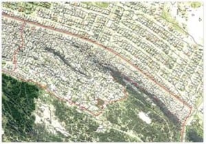
Contour Map from the VPUU
When creating maps we used three different methods. The simplest method was to have an outside source print or give us a map. This was most commonly done with Chris Berens at the VPUU. We received all of our topographic maps in this manner. The next method we used to get maps was Arc GIS. This geographic information software is a very powerful tool, but somewhat complex. We received one copy of the software from Professor Krueger at WPI. In addition we received much help in learning how to use it from Professor Winter at the University of Cape Town. Arc GIS is the software the 2008 Mapping team used, meaning all of their work was done in this format. It is an expensive program and WPI has limited licenses, preventing us from becoming familiar with it prior to arriving in South Africa.
Arc GIS allows for very detailed mapping and planning capabilities but because of its limited availability and steep learning curve, we used a third method for creating maps: Google Earth. This software is free to download from Google and very intuitive to use. It is not as powerful as Arc GIS, but has the advantage in availability and ease of use as well as including a few unique features such as Google SketchUp (which we did not use extensively) and the ability to add pictures of an area. The results of our mapping work were a combination of PDF, Arc GIS, and Google Earth data. Many of these maps were also printed. You may view a list of all our mapping data here.


