| Sponsor | Student Researchers | Goals and Objectives | Executive Summary | Final Report and Video |
Contents
Background
From climate change to loss of habitat, there are a number of pressing 21st century environmental issues. The lack of human connection to nature could be to blame and according to a study done by the Kaiser Family Foundation and the Center for Disease Control (CDC), “A child is six times more likely to play a video game on a typical day than to ride a bike” (Chiu, 2005). This statistic represents a growing disconnect between humans and nature that many environmentalists hope to address.
Mass Audubon is a non-profit Massachusetts-based environmental conservation organization that seeks to educate the general public on statewide environmental issues. The new Blackstone Heritage Corridor Visitor Center will be established at the site of a former, historically significant, industrial mill, geographically near the existing trails of Mass Audubon’s Broad Meadow Brook Wildlife Sanctuary (BMB) in Worcester, Massachusetts. The new Blackstone Visitor Center is projected to be completed by 2017. By blazing and developing a walking trail connecting the existing BMB trails to the Blackstone Visitor Center, Mass Audubon hopes to provide the people of Worcester County with a more interactive experience with nature.
Sedentary lifestyles and lack of engagement with nature contributes to a number of health issues, including obesity, which can have a number of immediate and long-term health effects, increased risk for diabetes and cardiovascular issues, and psychological effects, such as depression and low self-esteem (CDC, 2015). By integrating nature into one’s routine, he or she can lead a healthier life. One way to increase a person’s experience with nature is through education and exposure.
Interpretive nature trails can be an effective way to teach about the environment and connect people with nature in an experiential way (Ostermann-Sussman, 1993). Nature trails present an opportunity for people to engage with nature in a more personal way. In this case, the trail not only serves as a way for people to get outside, but as a way to learn about the history of Worcester, Massachusetts as well. By using a trail to link the Broad Meadow Brook Wildlife Sanctuary (BMB) to the future Blackstone Heritage Corridor Visitor Center, residents and visitors, alike, will be able to experience the nature and history of Worcester in a unique way.
Methodology
The primary goal of our project was to Global Positioning System (GPS) map and propose a trail connecting the existing trail network at BMB to the site of the new Blackstone Visitor Center. Secondarily, we also worked to identify key points along the trail where educational components interpret historical and environmental information for trail users. In order to accomplish this goal, we developed nine objectives broken down into three phases:
Phase 1: Understanding Broad Meadow Brook Trail Users
Objective 1: Identify our Target Demographic
Objective 2: Assess Current Trail User Perspectives
Objective 3: Connect with Surrounding Schools
Phase 2: Trail Planning
Objective 4: Determine the Most Feasible and Effective Trail-based Education Method to Implement at Broad Meadow Brook
Objective 5: Develop Educational Material to Use along the Trail
Phase 3: Trail Creation
Objective 6: GPS Map Ideal Trail Route
Objective 7: Identify Landowners Adjacent to Trail Path
Objective 8: Present Our Findings to Mass Audubon
Objective 9: Blaze the Trail
In phase 1, we sought to understand the trail’s target audience and most likely trail users. We conducted interviews with Deb Cary and Martha Gach, Central Sanctuaries Director and Conservation Coordinator, respectively, from BMB. We also conducted interviews with Devon Kurtz, the Project Manager from the new Blackstone Visitor Center, administered a survey to current trail users at BMB, and interviewed school officials from Holy Name Junior/Senior High School and the Vernon Hill School to gauge their interest in using the trail for educational purposes. In phase 2, we determined the most effective educational approach for the interconnector trail and then developed interpretive material to be used along this trail. To do so, we conducted interviews with Ms. Cary and Ms. Gach from BMB, as well as Ms. Melinda Learning, an award-winning environmental educator. We also developed case studies of other nature trails concerning the effectiveness of interpretive, or educational, components along them. In phase 3, we GPS mapped various trail routes, identified and met with landowners along the trail, and proposed our findings and recommendations for the best trail route and complementing, interpretive materials to Mass Audubon.
Findings and Recommendations
From the various research methods we completed, we identified numerous findings that allowed us to provide Mass Audubon with useful recommendations. In Table 1 we summarize our findings from the first two phases of objectives.
Phase 1 Findings: Trail Users
We found that the most frequent users of the trail will be the current users of the BMB trails, visitors at the new Blackstone Visitor Center, and students from the surrounding schools (Cary and Gach Interview, 2015; Kurtz Interview, 2015). We also found that these trail users enjoy viewing interpretive material and agree that the trail should be marked clearly (Howie Fain Interview, 2015).
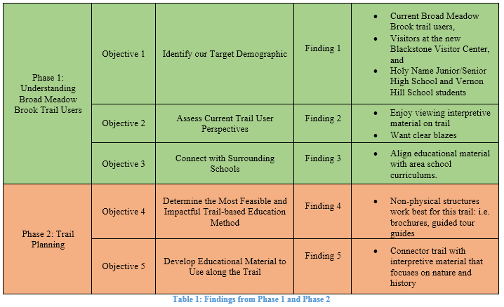
Phase 2 Findings: Interpretive Materials
In phase 2, we found that interpretive signposts, self-guided brochures, and guided nature walks are all effective educational methods to use along a trail (Cary and Gach Interview, 2015; Fain Interview, 2015; Learning Interview, 2015; Osterman-Sussman, 1993). However, due to the decision by BMB to bypass investing in physical structures, such as interpretive signposts, along this trail because of the potential for vandalism, we recommend educational components that are less prone to vandalism. Since we were developing a connector trail, we wanted to capture the interests of the visitors from both centers. Consequently, we created interpretive, educational material for the trail that highlights each centers’ focus: nature and history (Cary and Gach Interview, 2015; Kurtz Interview, 2015).
Phase 3 Findings: The Ideal Trail
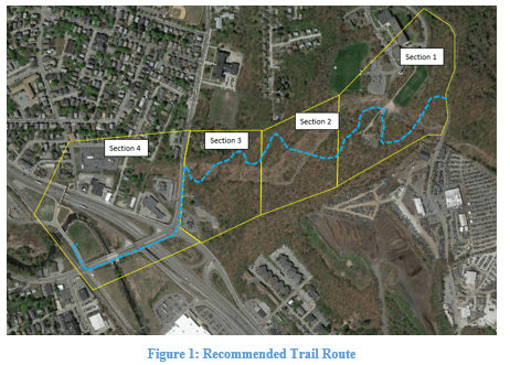
In phase 3, we found that no formula exists for an ideal trail, instead, a trail must be blazed taking into consideration unique features of the environment, and perspective of likely users. The existing trail network of BMB consists of trails of varying makeups and difficulties. The connector trail connecting the existing trail network to the Blackstone Visitor Center could take many different shapes. In order to identify the most feasible, implementable, and effective connector trail we separated it into four distinct sections as illustrated in Figure 1. Each section has unique characteristics that create the opportunity for different paths. Ultimately, because of existing land conditions, each section has potential for various options. Figure 1 also shows, in blue, the final trail route we recommended to Mass Audubon. We ultimately felt that the ideal trail for this area should include two unique views, the view of the Blackstone River Valley and the view of the Holy Name wind turbine, as well as three unique habitats, the Black Oak savanna, the low lying grasslands underneath the power lines, and the wetlands.
Recommendations
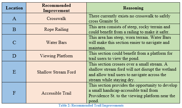
At the conclusion of our research, we provided BMB with detailed recommendations for the best possible trail route, options for trail improvements, specific environmental and historical feature to highlight along the trail, and the methods by which to present these features to trail users. Figure 2 and Table 2 illustrate the points where we recommend the trail be improved.

The accompanying chart, Table 2, summarizes our recommendations for improvements at these six locations.
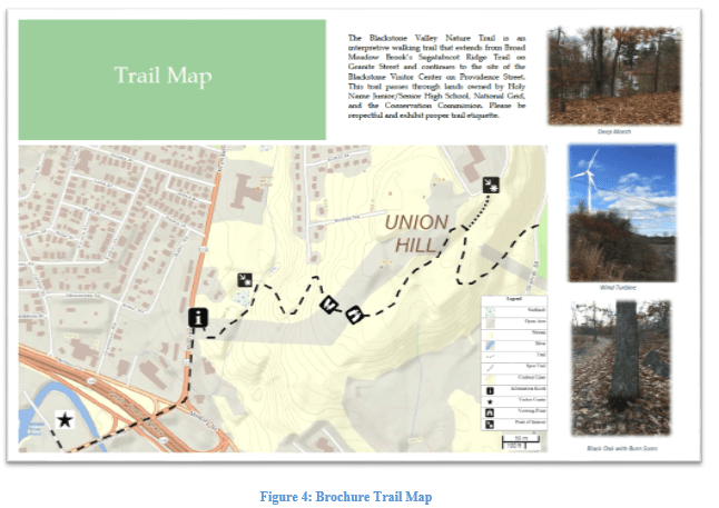
We also recommend a self-guided brochure to accompany the trail because we found that it is an effective and low cost educational method that does not have the potential to be vandalized. Figure 3 and Figure 4 show a draft brochure BMB might use.
As the visitor center opens and the trail becomes used more frequently, we recommend that BMB and/or the Blackstone Visitor Center offer guided tours along the trail. We found that guided nature walks, which allow people to explore and ask questions about what interests them, are most effective for learning (Fain Interview, 2015; Learning Interview, 2015; Osterman-Sussman, 1993). We also recommend other educational activities, such as scavenger hunts in the form of Geocaching, to increase trail use, because these types of activities can promote exploration and discovery.

We recommend a kiosk at the trailhead where the street trail meets the natural surface trail on Providence St., as seen in Figure 4. This kiosk, which is less prone to vandalism because it is on a busy street, will inform people of the trailhead and where the natural trail begins. The kiosk will have a map identifying both visitor centers, and a description of the trail and some of its features.
We also recommend a viewing platform made of rock or cement where the trail crosses under the power lines. We recommend using a granite slab to tie in with the history of the granite quarries along the trail. This platform would most likely only be found by those looking for it while walking the trail and therefore, has little potential to be vandalized. The viewing platform would be flush to the ground and have arrows on it pointing up and down the power lines in the directions of the wind turbine at Holy Name and the view of the valley, respectively. This platform will be located at an area where there are multiple large rocks, providing people with the opportunity to take a break and children to play or climb on the large boulders.
Conclusion
Mass Audubon tasked us with examining potential trail routes connecting the existing trail network of the Broad Meadow Brook Sanctuary to the future site of the Blackstone Heritage Corridor in Worcester, Massachusetts. This trail would be used to educate residents and visitors, alike, of the nature and history of the region. We determined the area’s landowners and the physical features to determine the best possible trail route and interpretive aspects.
As a result of research, we have determined that the ideal way to connect residents and visitors with the natural areas surrounding Worcester is through the trail outlined above. We recommend that this trail feature multiple scenic view points and an accompanying brochure to educate the trail’s users of the ecosystem and history surrounding them. In addition, connections can be made to the surrounding schools as a way to build community partnerships through the trail.