

Trail View
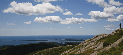
The 2016 Trail View team continued, and completed, the research started in 2012 of creating online, detailed 360-degree interactive trail views of the 125 miles of hiking trails in the Acadia National Park. The combined effort to realize all of the hiking trails in 360-degree views resulted in nearly 20,000 images and over 50GB of data. WPI’s interest in the Trail View project relates strongly to the National Park’s interest in engaging visitors with interpretive media that offer interactive experiences, convey information based on current scholarship, and are accessible to the broadest range of the public. Along with the interactive 360-degree panoramic trail view, the 2016 WPI team began to include 360-degree virtual reality video as part of the interactive experience. The educational and informational benefits of making the trails visually accessible to a wide population of outdoor enthusiasts is invaluable.
In preparation for the Acadia National’s Park Centennial in 2016, the Trail View team concentrated on the hiking trails in the area of Northeast Harbor. That location is significant because the origins of conservation on Mount Desert Island can be traced to that area. It was a clear, cold night in March 1880, when Harvard student Charles Eliot gathered six of his friends together in 34 Grays Hall in Cambridge to discuss a camping expedition to  Maine. Over the course of the summer, and for the next decade, members of the Champlain Society conducted the first natural history surveys of the island. They also influenced the eventual purchase and protection of land that would become Acadia National Park.
Maine. Over the course of the summer, and for the next decade, members of the Champlain Society conducted the first natural history surveys of the island. They also influenced the eventual purchase and protection of land that would become Acadia National Park.