

Innovating the Nantucket Tree Inventory
| Sponsor: | Nantucket Land Council |  |
| Sponsor Liaison: | Emily Molden | |
| Student Team: | John Amaral, Marc McFatter, Yanniode Peri-Okonny, Lauren Thompson | |
| Abstract: | The goal of this project was to help the Nantucket Land Council enhance urban tree appreciation and maintenance records in downtown Nantucket. To do this, we established a tree inventory system that utilized GIS location-tracking technology and data collection procedures and created a mobile website prototype designed for public education on downtown trees. The inventory system led to several project deliverables, including a spreadsheet of tree data, a map displaying the GIS locations of each tree, and instruction manuals describing the inventory process. The mobile website prototype, “ACKnowledge the Trees,” had both a tree scavenger hunt and an interactive tree tour mode. Recommendations were made for both the inventory system and mobile website for future project improvements. | |
| Link: | NLC_final_report NLC_final_presentation |
|
Executive Summary
Introduction
Trees are often overlooked in today’s society. Trees provide numerous benefits, including shade, oxygen, and mental support, and as such they should be maintained properly and appreciated through educational materials. On Nantucket, the downtown trees add natural beauty and historical importance to the island.
Both the Nantucket Land Council (NLC) and Department of Public Works (DPW) promote tree maintenance and education on the island. In the 1980’s, the DPW collected tree attributes such as tree species and height for all the downtown trees, and in 2016, that data was placed into a tree inventory spreadsheet. The NLC used this data to promote tree education by creating a brochure of the downtown trees and hosting public tree tours.
Mission, Objectives, and Methods
The goal of this project was to enhance urban tree appreciation and maintenance records in downtown Nantucket. To do this, a new tree inventory system containing reorganized data from the old DPW tree inventory and newly-collected data was created. The inventory is designed for multiple purposes, including marking each tree’s location on a map of the island, historical and current data comparisons, and prototyping an engaging mobile website for tree education. The project was broken down into the following objectives:
- Improve the Nantucket tree inventory system by identifying attributes to record in the new inventory, creating a data dictionary to collect the data, and organizing the tree data into an easily-accessible spreadsheet.
- Collect data on town trees in the downtown area by collecting GIS locations and tree attributes for each tree, processing and entering the data into the inventory, and mapping the trees’ GIS locations.
- Develop methods to promote tree education through interactive experiences by developing a mobile website prototype that teaches users about the trees on Nantucket.
Results and Outcomes
The new tree inventory system was made up of components such as a list of important tree attributes, a data dictionary for recording the attributes, and a spreadsheet containing the collected data (Figure 1). The inventory system can be used to create a map displaying tree locations, compare present and historical data, create instruction manuals for using the inventory system, and promote tree education via a mobile website.

Figure 1: The components and products of the tree inventory system.
System Overview
The finalized attribute list, containing the most important data to record from each tree, is converted into an electronic format known as a data dictionary. The data dictionary is then installed on a GIS Trimble unit (Figure 2), allowing the user to record attributes as the GIS coordinates of each tree are being recorded.

Figure 2: A GIS Trimble unit using the data dictionary for
data collection in the field (Project Team Photo).
After collecting data, the data is exported into an Excel spreadsheet that serves as the tree inventory. A revised spreadsheet exists for easier interpretation and integration with applications such as the mobile website that can be edited at any time, allowing the NLC and DPW to easily modify the information.
The ACK Tree Inventory System Manual accompanies the tree inventory system and contains procedures that describe modification of the data dictionary, operation of the GIS Trimble unit, tree data collection, processing the collected data into a spreadsheet, and marking the GIS tree locations on a map, as well as supplementary materials such as a list of equipment needed and a tree identification chart.
Using the System
Once this inventory system was established, it could be used for many different purposes, including:
- Downtown Trees data layer – the GIS location of each tree can be marked on a map of the island (Figure 3). The map can then be sent to the Nantucket GIS specialist for the creation of a data layer showing each tree’s location as a point on a map on the Nantucket town website.
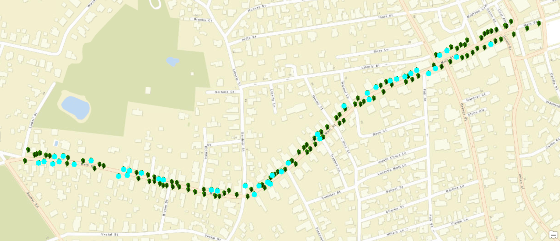
Figure 3: A GIS map that shows the locations of each tree surveyed.
Each dot represents a tree, and the blue dots represent American elms.
- Data analysis – with the updated data in the spreadsheet, the NLC and DPW can observe trends in the downtown tree population using data from previous years, such as the historical tree data from 1986. An analysis example is shown in Figure 4.
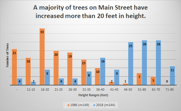
Figure 4: A bar chart comparing heights of Main Street trees in the 1980s and 2018.
- Mobile website – “ACKnowledge the Trees,” the prototype for an interactive and educational mobile website about the downtown trees (Figure 5), has both an interactive scavenger hunt (“Nantucket Tree Adventure”) and a general tree tour mode. In the scavenger hunt, users follow clues to find specific trees and access that tree’s information from the tree inventory. In the tree tour mode, users can tap on any tree in the area to access data from the inventory such as species, height, or when the tree was planted.

Figure 5: The tree guide “Oakley” who guides the user
in the scavenger hunt of the mobile website.
Recommendations
The following recommendations are for the NLC and DPW to consider when continuing work on the tree inventory:
- Create new identification numbers for the trees – identify each tree with the street name and a unique number and make new medallions with this naming convention.
- Collect data in both summer and winter – identify the trees by their leaves in the summer and observe damage and maintenance issues more easily in the winter.
- Use the data analysis for maintenance plans – based on trends in tree growth, create maintenance protocols for specific tree species and individual trees.
- Proceed with mobile website development – add more functionality to the website, such as adding more quests for the scavenger hunt, making the tree identification flowchart interactive, connecting the website to an online version of the data spreadsheet, etc.
- Increase the advertisement of the mobile website – advertise the mobile website in the NLC’s downtown tree brochure and in the Nantucket visitor’s center, add a prize for completing the scavenger hunt, etc.