

Developing Recommendations for a Management Plan in La Playuela Beach, Puerto Rico
 Sponsoring organization: Departamento de Recursos Naturales y Ambientales
Team members: Austin Rose (Computer Science ’17), Tim Marschall (Management Information Systems ’17), Tyler Tao (Mechanical Engineering ’17)
Executive Summary: We are a team of students from Worcester Polytechnic Institute, who completed a project in coordination with Puerto Rico’s Department of Natural and Environmental Resources (DNER). The purpose of the project was to produce recommendations regarding the specifics of a future management plan for La Playuela – a protected area within the DNER’s jurisdiction, which they identified as critically in need of new regulation. This document is the final product of that project.
La Playuela is officially recognized as a National Natural Landmark for its unique geography, diverse collection of vegetation, and its importance as a habitat for a number of endangered or endemic species. At the same time, its small strip of beachfront is a frequent destination for local and international tourism alike. In the past 15 years especially, La Playuela has seen an unprecedented spike in visitors. This has resulted in proportional degradation to the ecology. Among the many problems: mangroves are dying, wildlife species are nesting less frequently, and litter is more abundant. We used multiple methods in order to understand La Playuela’s recent development, and develop educated strategies for its management. We conducted personal interviews with various personnel who either knew personally about the problems facing La Playuela, or who had previously worked on management plans in different regions of Puerto Rico. We constructed and administered a written survey to beachgoers to evaluate the level of public information on these issues, and to gauge what management strategies would be most well received. We compared satellite images of the area to observe shrinking plant life density. Lastly, we applied Geographical Information Systems (GIS) techniques to measure spatial parameters of the beachfront and calculate an occupancy capacity.
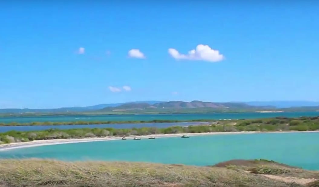 Initially, we considered recommending that the new management plan be modeled on a framework called the Limits of Acceptable Change (LAC). However, a main result of our interviews with experts on the LAC was that La Playuela is not an ideal candidate for an LAC management plan; the LAC is an excellent preventative measure, but La Playuela is not only in need of prevention – it is in need of restoration. The main result of our interviews with people who have witnessed La Playuela’s degradation first hand was that the strip of mangrove forest adjacent to the beachfront is the area most critically in need restoration. Beachgoers frequently set up their equipment beneath the mangroves for shade, and to use the branches for hanging bags. This regular abuse has taken a major toll on the once dense strip of mangrove.
Our primary recommendation for the new management plan is that it disallow people from occupying the area within the mangroves – restricting them to stay on the beachfront. To accompany that restriction, we propose a proportional reduction in the maximum number of cars allowed by the parking facility, so to account for the reduction in usable beach space. By calculating the square footage of non-mangrove beachfront, considering the typical size of a group, and how much space they should need to be comfortable, we arrived at our proposed parking capacity: 136 cars. After that point, the beach does not have space to healthily accommodate everyone.
In addition to this occupancy limit, we proposed a number of alternative strategies that may help curb degradation without explicitly restricting access. The results of our surveys helped indicate which of these strategies will be the most well received by the public. Finally, we offered a few methods for evaluating, in future years, how successful a management plan has been in its restoration goals.