

Assessment of the Rio Mavillas for Inclusion in Puerto Rico’s Heritage River Program
 Sponsoring organization: Departamento de Recursos Naturales y Ambientales
Team members: Lindsay Gurska (Biology & Biotechnology ’18), James Vorosmarti (Civil Engineering ’18), Kevin Walsh (Civil Engineering ’18), & Michael Wilkinson (Mechanical Engineering ’18)
Download the final presentation.
Download the team’s Monte Choca Brochure.
Executive Summary: Land use changes, such as replacing forest for agriculture and urban land use can have detrimental effects to the ecological integrity of freshwater ecosystems. Land use changes can alter physical, chemical, and biological components of rivers, all of which encompass stream degradation seen through elevated concentrations of nutrients and contaminants, altered channel morphology, and reduced biotic richness. The Department of Natural and Environmental Resources (DNER) in San Juan, Puerto Rico is the agency responsible for creating mechanisms for the protection of rivers and streams in Puerto Rico. As enacted by Law 180, the DNER is responsible for carrying out Puerto Rico’s Heritage River Program, and thus has the ability to regulate and create policies to protect, preserve, and restore rivers that display minimal anthropogenic alterations. In order to meet the criteria for inclusion in Puerto Rico’s Heritage River Program, the DNER is required to evaluate many factors, such as a river’s water quality, socioeconomic value, current hydrology, and local community development. Upon designation as a Heritage River, a river gains public recognition for having natural, recreational, cultural, and historical value. Thus, the Heritage River Program allows the DNER to protect the natural characteristics of rivers that have minimal anthropogenic modifications to retain its ecological integrity for future generations to enjoy.
Currently, Puerto Rico’s Heritage River Program consists of twenty rivers, with the headwaters of these rivers beginning in a state forest protected by the DNER. Since the headwaters of these rivers begin in an already protected area, the water quality and stream biota are generally healthy, thus making inclusion into the program relatively simple. However, more recently, the DNER is exploring the protection of rivers that do not begin in a protected forest. The Rio Mavillas, located in the Monte Choca State Forest, does not begin in a protected area, but rather flows through one. Due to a high demand for protection triggered by potential anthropogenic activity, the Rio Mavillas will be the first river of its kind being assessed for inclusion in Puerto Rico’s Heritage River Program. The Monte Choca State Forest was established in 2003, making it a relatively new state forest in Puerto Rico with little urban development in the area. The forest offers a variety of recreational attractions, with the most well known being the Bamboo Cathedral. Additional attractions include a camping area, hiking trails through the forest, and the Rio Mavillas for recreational activities. The DNER wishes to include the Rio Mavillas in Puerto Rico’s Heritage River Program to protect and preserve the water quality, aquatic species, and ecosystem services of the river, as well as prevent alterations to the geomorphology, hydrology, and surrounding landscape.
Project Goal and Objectives
The goal of this project was to provide geomorphology, water quality, and aquatic diversity data, as well as create an interpretive map and survey, to support inclusion of the Rio Mavillas in Puerto Rico’s Heritage River Program. For determination of the river’s geomorphology, water quality, and aquatic species abundance and diversity, the DNER has requested that three clear protocols be conducted (Objectives 1-3). Additionally, the DNER provided a river usage survey to be modified, so that future administration of the survey will yield data assessing the knowledge of ecosystem services provided by rivers (Objective 4). Lastly, an interpretive map of the Monte Choca State Forest was created, highlighting key areas of interest to the local community and forest visitors as well as trails to encourage recreational use of the state forest and Rio Mavillas (Objective 5). The primary objectives of this project are as follows:
1. Determine the geomorphology of the Rio Mavillas according to the Rosgen Stream Classification System.
2. Determine the stream conditions of the intended segment of the Rio Mavillas by using the Visual Assessment Protocol for Puerto Rico Streams.
3. Assist in the collection and identification of stream macroinvertebrate in order to determine the water quality of the Rio Mavillas.
4. Modify and adapt the “Cuestionario de Usos de Rios” (River Usage Survey) provided by the DNER.
5. Create an interpretive map of the Monte Choca State Forest using ESRI ArcGIS software.
Methodology
The Rosgen Stream Classification System is a well-characterized method to determine the geomorphology of a river, and thus serves as a tool for predicting a river’s behavior to future changes (i.e. climate change, land use changes) and also for the development of restoration projects. To determine the geomorphology of the Rio Mavillas, Level I and Level II classification was completed. Level I classification categorizes rivers based on basin relief, landform, and valley morphology. Level II classification, which is primarily collected through surveying cross-sections, topographical maps, and channel material assessment, categorizes rivers based on physical characteristics such as sediment supply, stream sensitivity to disturbance, channel responses, and habitat potential. The five major data components required for the Rosgen Stream Classification System are entrenchment ratio, width/depth ratio, sinuosity, channel slope, and channel material. Cross-section surveys and dominant channel material assessment were completed at three different locations along the Rio Mavillas that were good representatives for Rosgen classification. From the GPS and channel material data generated, graphs and aerial photographs of each cross-section were created to generate the data requirements in order to determine the Rio Mavillas stream type classification, and thus predict its potential for success in Puerto Rico’s Heritage River Program.
The DNER has adopted protocols from other river conservation projects in order to determine if a river’s physical conditions meet the requirements for restoration and protection. One example is the Visual Assessment Protocol for Puerto Rico Streams, which was adapted from the USDA Hawaii Stream Visual Assessment Protocol to the more prevailing conditions of the rivers in Puerto Rico. The protocol is divided into two parts: the general description of the river and a physical evaluation of the river. For the general description of the river, information was obtained from the US Geological Survey and interviews with community leader and Monte Choca State Forest manager Alberto Rivera. For the physical evaluation of the river, ten major elements – turbidity, plant growth, channel condition, channel flow alteration, percent embeddedness, bank stability, canopy, riparian zone condition, habitat availability, and the amount of visible trash/litter – were scored along three 100 meter transects of the river. From these scores, a stream index was calculated, thus providing a characterization of the river’s water quality and conditions within and around the stream that could improve from restoration efforts.
Macroinvertebrate are organisms without a backbone, visible to the naked eye, and can be collected by mesh nets; examples include insect larvae, worms, shrimp, and snails. Macroinvertebrate tend to remain in their original habitat, therefore the specific families of these organisms present in a habitat are informative of ecosystem health and river water quality. A rapid bioassessment multi-habitat approach to the macroinvertebrate collection was conducted on three 100m sections of the Rio Mavillas. By visually assessing each section, the percentages of each type of habitat were determined. A total of twenty jabs (samples) per transect were collected, proportionate to the present habitats within each of the 100 meter transects. The process of taking jabs with the mesh net involved placing the net approximately one foot downstream and causing a disturbance with our feet for approximately thirty seconds, freeing any organisms from the habitat and allowing them to flow downstream into the net. The net was completely washed out into a Ziploc bag, and a label placed inside for later identification of the sample. These samples were analyzed and observed through a microscope to sort all macroinvertebrates collected.
The DNER provided a River Usage Survey that required assessment for its ability to measure the knowledge of ecosystem services provided by rivers. In order to modify this survey, research on the four major ecosystem services provided by rivers – provisioning, regulating, cultural, and supporting – was completed. Questions were then added and modified to accurately accomplish this goal, as well as to instill trust in the participant to provide honest responses. These modifications also facilitate the process of statistical interpretation. Lastly, the survey was sent to Professor Luis Santiago, from the University of Puerto Rico, who has previously developed similar surveys, and he analyzed the questions and structure of the survey in order to assess their potential for bias, ease of analysis, and ability to produce the desired data.
In order to create an interpretive map of the Monte Choca State Forest, a GPS was used to collect locations for key points and trails. This was accomplished using a Trimble Juno 3D handheld GPS device provided by the DNER. This device recorded the locations of key points of interest in the forest as determined by our group, the DNER, and Alberto Rivera, and always had a PDOP (Position Dilution of Precision) value of less than 4 in order to ensure accuracy. Points along the trails in the forest including bends, intersections, and open areas were recorded in order to generate trail maps. Base data layers including municipalities, bodies of water, and a map of the delimitation of the Monte Choca State Forest were obtained from the DNER, and this information was uploaded on ESRI’s ArcMap software and arranged in an aesthetic format. Additionally, pictures were included of some of the more notable points of interest. The trails generated were color coded and labeled, noting the difficulty, length, and approximate time to complete. A legend was also provided to identify the points of interest marked on the map. Lastly, a map of the three transects of the Rio Mavillas that were used to conduct the various protocols necessary during the project was created as a reference.
Results and Discussion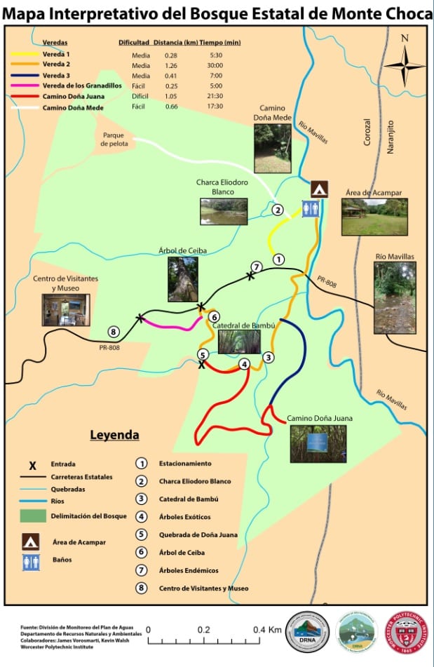
Level I and Level II classification of the Rosgen Stream Classification System were successfully completed to allow for interpretation of the geomorphology of the Rio Mavillas. Upon analysis of the three different cross-section surveys, the entrenchment ratio, width/depth ratio, sinuosity, dominant channel material, and channel slope were determined, and were used with the Rosgen Stream Classification System guide to classify the Rio Mavillas as a B4c stream. B4 stream types are characterized as being moderately sensitive to disturbance, having excellent recovery potential, moderate sediment supply, low erosion potential, and moderate vegetation control. This suggests that any future land use changes would seriously impact the ecological integrity of the Rio Mavillas, thus reinforcing its inclusion in the Heritage River Program.
The Visual Assessment Protocol for Puerto Rico Streams was successfully completed at the three 100m transects of the Rio Mavillas. All three transects scored high values in the ten elements evaluated, thus receiving stream index values of 1.82 out of 2.0, 1.95 out of 2.0, and 1.82 out of 2.0, respectively. These scores, proving high water quality, are indicative as to why the Rio Mavillas should be protected by the DNER under the Heritage River Program because it will help retain the quality of the river for future generations to enjoy. It will also protect the river from future anthropogenic modifications that have the ability to diminish water quality and stream biota. As a final point, during field observations of the Rio Mavillas, a bridge and remnants of a car were found between the first and second transect. These structures have the ability to alter the riparian zone and erosion rates within the river, and thus deserve attention for restoration by the DNER.
The macroinvertebrate multihabitat bioassessment collection was successfully completed. From the samples collected, the individual macroinvertebrate were successfully identified by our group and staff of the DNER at the University of Puerto Rico, Rio Piedras Campus using microscopes and other equipment provided by the University’s Natural Science laboratories. In total, 890 organisms were collected from 19 different families. A biodiversity value of 1-10 corresponded with each family, depending on how susceptible the family was to poor water quality. A higher value meant the family required better water quality to survive. The values of the families were then totaled, and by using a water quality index the value obtained of 84 was able to tell us that the water quality of the Rio Mavillas is good and not contaminated or altered in a sensitive manner. This rating is the second highest before excellent water quality, which further supports the inclusion of the Rio Mavillas in Puerto Rico’s Heritage River program.
The River Usage Survey provided by the DNER was successfully modified in order to collect data on the extent of knowledge of ecosystem services provided by rivers. In addition to adding a question pointing out the four main ecosystem services, questions were modified to eliminate ranking responses, generalized for the use of the survey for any river in Puerto Rico, more descriptive for clarification and ease of analysis, and altered to remove the possibility of biases responses. The format of the survey was also restructured in a manner suggested by Professor Santiago to instill trust in the participant. This survey is now ready for administration and will aid the DNER in assessing the success of the Heritage River Program.
An interpretive map of the Monte Choca State Forest was successfully created and will be printed on signs in five locations within the forest and distributed as part of an informative brochure. It is the goal that this map will help visitors navigate the forest trails and visit the various points of interest located within the forest. This ease of navigation could help to increase use of the forest by locals and tourists alike. The brochure in which the map is also placed in will further carry out this goal, thus fulfilling the Heritage River Program’s goal of retaining natural characteristics of rivers (and its surrounding land area) for future generations to enjoy.
Conclusion
All objectives were achieved during the completion of the project, and thus this project successfully provided the DNER with supporting data to include the Rio Mavillas in Puerto Rico’s Heritage River Program. The results of these objectives also show the potential that designation will have on the Rio Mavillas, as they show that despite the river having high water quality and aquatic species abundance and diversity during the rainy season, the Rio Mavillas is susceptible to change and needs protection from anthropogenic modifications to retain this ecological integrity. Overall, all objectives met support the DNER’s desire of designating the Rio Mavillas a Heritage River and set the framework for a management plan to allow the program to carry out its goal of protecting the natural features of rivers for future generations to enjoy.