

Executive Summary
Introduction
Findings
Recommendations
Introduction
According to numerous climate scientists and institutions, including the Intergovernmental Panel on Climate Change (IPCC), climate change is expected to cause more frequent and severe floods worldwide (Arnell & Gosling, 2014; Khan 2012). In New Zealand, the Hutt Valley, located north-east of Wellington with a population of around 130,000 people, has experienced major floods in 1976 and 2004 and is likely to be more vulnerable to climate- induced flooding (Statistics New Zealand, 2013).
To address flooding, The Hutt Valley Flood Management Plan (FMP 2001) was developed in the 1990’s by the Greater Wellington Regional Council (GWRC) through a community consultation process, and has relied on river engineering, afforestation, and limited building construction in flood-prone areas (Greater Wellington Regional Council, 2001; Greater Wellington Regional Council, 2013). The FMP is currently being reviewed by the Greater Wellington Regional Council in order to take into account the increased risk of severe flooding associated with climate change.
In order to update the FMP in ways that respond to the views of the local community, the GWRC asked us to investigate public perception of flood risk, climate change, and the effectiveness of flood mitigation measures implemented under the plan. To accomplish this goal, we developed four objectives to guide our project:
- Understand the physical geography and hydrology of the Hutt River
- Understand current government flood management practices and community outreach strategies
- Assess local business perspectives on flood risk, climate change, and flood planning
- Investigate public perception of flood risk and climate change and what factors shape this perception
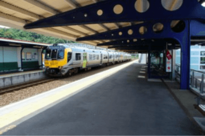
In order to accomplish the first two objectives, we spent the first couple of weeks touring the area as well as holding meetings with various members of the GWRC and HCC as well as other various key members of the public. We then went on to investigate the public’s perception. To do so, our group designed a five to ten minute convenience sample survey. The questions were comprised of both open-ended questions and closed-ended questions that led to a variety of both qualitative and quantitative responses. During our surveying time, we also interviewed five businesses in order to gain their perspective. We asked businesses a more in-depth set of questions which were meant to probe deeper into their views, as well as understand their thoughts on the current planning process. While surveying, we targeted high traffic areas in the Lower Hutt City to maximize our number of respondents, as well as obtain a broad range of demographics from the public. An example of a survey location can be seen in Figure A.
 Figure A: Petone Railway Station
In total, we were able to conduct 202 surveys in the Hutt Valley. Upon concluding surveying, we compared the responses between different questions and the demographics of the survey participants in order to find relationships in the data. To do this, we used the chi-squared test for variable independence. To run the chi-squared testing we used a combination of several computer scripts. When a significant pairing was found, the scripts then formatted the data into a human-readable and Excel-compatible spreadsheet. The data in the spreadsheet was used to illustrate relationships between the variables in questions, both textually and graphically via the use of charts.
Findings
Residents of Hutt Valley believe that the area is likely to experience a major flood soon, however blind trust in those responsible has resulted in a disproportional amount of concern. Flooding in the Hutt Valley is viewed as a high frequency, low impact event, confining public perception of flood impacts to transportation and ability to work rather than personal impacts, such as residential damage. Participants underestimate the risks associated with flooding, and the realistic characteristics of a 1 in 440 year flood are foreign to most.
The public had limited knowledge about flood management, despite their concern of the flooding. Few were able to correctly identify the current flood protection manager or provide detail about past flood protection measures. Participants were understandably confused as to who controls flood protection of the Hutt River, as division of responsibility is quite complex. Less than a third of the survey participants were able to correctly name the GWRC as responsible for flood protection, as can be seen in Figure B.

Figure B: Responses for who is responsible for flood management
A respondent’s source of knowledge was found to impact their level of knowledge and understanding of flood protection. Those receiving information from the media were more likely to identify the HCC as responsible for flood protection than those obtaining information from government sources. Additionally, respondents receiving information from government sources were found to be far more likely to believe that the current flood measures have reduced the risk of flooding than those receiving information from the media.
Residents overwhelmingly believe that climate change is happening and needs to be addressed. Of our respondents, a quarter admitted that they knew little or nothing about the issue, but three-quarters knew enough to at least realize its potential impact on flooding, as can be seen in Figure C.

Figure C: Will climate change impact flooding?
However, less than half of the respondents that believe climate change will impact flood risk think that flood risk will increase. This is the opposite of what climate change and flood models predict. The majority of participants did not know any methods to adapt to the impacts of climate change, with most responding with mitigation efforts, such as reducing emissions by taking public transportation or biking to work. Few offered adaptations that could be done on the local level.
Of the five business owners we interviewed, none felt included in the flood planning process. However, not many seemed to want to be involved. The Chamber of Commerce seemed to be the only one that was concerned, and felt that more businesses should want to get involved . When asked how this could be done, two business owners suggested more public forums, while others suggested business-centered focus groups. Several stated that the Chamber of Commerce would be an excellent source to disseminate information on the issues and how to become more involved.
In meeting with the GWRC, it was found that they rely heavily on government publications in the form of their website, newsletters, and newspaper articles to circulate information regarding upcoming plans. They then hold workshops and open forums that allow stakeholders to express their opinions on plan options. The council incorporates feedback from these meetings into their options. With most of those aged 18-25 unable to identify the GWRC as responsible for flood risk management, as seen in Figure D, it is possible that the information being sent out is not reaching everyone that it needs to.
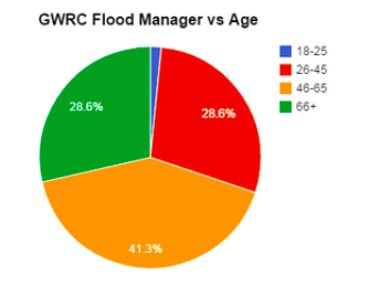
Figure D: Age distribution of those who identified the GWRC as flood risk manager
Recommendations
The GWRC should more clearly communicate flood risk in the Hutt Valley, and stress that the area is always going to be at risk of flooding, despite any and all future flood protection works. This could be done by making the flood risk more personalized, such as reframing the statistic of a “1 in 100 year flood” as “a 26% chance of flooding during a 30-year mortgage”. While these two statistics state the same fact, the latter is more relatable. Another way to do this would be to create an interactive simulation of flooding potential in the Hutt Valley in order to make the problem more relatable to the people affected by it.
Creating a pamphlet going over information on how to be prepared for a flood would allow the public to take individual action. Other individual ways to become involved could be keeping the river clean by not dumping rubbish in it. Signs could be posted along the river that explains how rubbish can clog drains that are supposed to help protect against flooding, as well as the damage to native species. Taking care of your property to keep drains clear is another way the public could become involved.
The GWRC already has multiple resources to distribute information and receive feedback from the public. However, it was found that most of the public does not know where to access this information, and has therefore received none or limited knowledge from reputable sources. The best way to broadcast this information would be through public databases such as the Wellington library network, the Lower Hutt Chamber of Commerce, or other media outlets such as local newspapers like the well-read Hutt City News. The Wellington Library Network has the ability to reach out to over 200,000 members, while the Chamber of Commerce can reach out to 3,500 businesses. An additional method to contact the public could be the use of media outlets, such as their own social media pages, to communicate upcoming events and the importance of the topics being discussed. Any and all methods should promote the online tools the GWRC already has available, as currently only a fraction of the population seems to be familiar with them.
We suggest that the GWRC involve the community sooner in the planning process than is done currently. For businesses, this could be done in collaboration with the Chamber of Commerce, as they can reach a broad member base and have influence in the business community. Additionally, focus groups with several members of the business community could be run earlier in the process to obtain the feedback from this important stakeholder.
Moving forward, we suggest that the GWRC conduct further research in several key areas. During our study we interviewed five businesses, which is not a representation of the business community as a whole. Speaking with a larger number of businesses as well as a wider variety would be useful to gain a better perspective of these key stakeholders, and understand the differences between the different sizes and types of businesses in the area. The influence of major events could also be explored. If a major flooding event were to occur elsewhere in New Zealand, it would be interesting to see if and how that affected the Hutt Valley’s view on flood risk. Additionally, researching a respondent’s knowledge of flood risk based on whether or not they live in the floodplain could provide additional relationships to compare to the questions.