Infrastructure Design
Infrastructure Design
Designing the infrastructure of an area is central to spatial mapping and urban planning. Infrastructure encompasses many integral elements of the urban environment, such as roads and paths, water and sewage lines, electricity and lighting, and building placement.
There are several topics that are central to infrastructure planning. One such topic is the “five elements” of a city as specified by Kevin Lynch. The first of the five elements is the concept of paths. They don’t have to be strictly sidewalks, but simply commonly traveled routes (Lynch, 1960). Often times the paths are decorated to be visually appealing, although that is not a primary concern for redeveloping informal settlements such as Monwabisi Park. The second concept is the idea of edges. In the context of Monwabisi Park, an edge could consist of a wall or perhaps the edge of the informal housing area along the back side of the park. Districts are the third element of a city and are an important part of our planning. They are sections of the city, or park, “which the observer mentally enters inside of, and which are recognizable as having some common, identifying character” (Lynch, 1960). An example of a district in Monwabisi Park that has already been implemented is the area around the Indlovu Center. The next concept is central to the VPUU’s design plan. Nodes are “strategic spots in a city into which an observer can enter, and which are the intensive foci to and from which he is traveling” (Lynch, 1960). Nodes don’t have to be a singular, physical object, but in the plans that the VPUU has proposed, their “safe nodes” are just that. By making these safe nodes the primary focus of many people in the immediate area, the VPUU hopes it will deter crime and promote a sense of community safety. Finally, landmarks are the other element of a city. They are fairly self explanatory, consisting of a single unique element that stands out from the rest or has some kind of significance. In a way, the VPUU’s safe nodes are also landmarks as they can help with navigation throughout the park and are easy to spot.
Roads
Roads are a fundamental piece of the urban planning puzzle. In the practical sense, roads are a way to get from point A to point B. In reality, though, one must consider that the quality and layout of roads significantly affects the dynamics of transportation in the community. Because Monwabisi Park is such a tightly knit community, any major change in their current infrastructure is bound to change the social climate of the area. Adding structured roads throughout the area will inevitably change the way in which people travel, and will alter the flow of people and vehicles within the park. Figure 8 shows the current roads (in red) as well as the roads WPI students proposed in 2008 (in yellow). Currently, people travel in very direct paths from one place to another, walking between shacks and on very informal footpaths. The addition of more permanent infrastructure would draw people away from obscure (and potentially dangerous) means of navigating throughout the park and promote regular routes of travel. This could have economic implications as well, as businesses may benefit more from being on a heavily trafficked street than they would from being on a footpath or alleyway. As mentioned before, emergency vehicle access is something that is severely lacking in Monwabisi Park. Sanitation services also have a difficult time reaching any of the public facilities and are thus unable to tend to them. The obvious problem is a lack of structured, well-maintained roads; however the solution to the problem is not so simple. The layout of the roads will play a pivotal part in the security of the park as well as its economic efficiency and communal benefits. Indirectly, the layout of the roads will also affect the sewage system design and the electricity grid.

Figure 1: Proposed Roads for Monwabisi Park (Franck, Mayo, Tomasko, & Xie, 2008)
Since flooding is a major issue in Monwabisi Park, roads also serve as a primitive irrigation system by collecting and channeling water to either sewage pipes or other drainage areas away from the informal shacks. These roads don’t necessarily have to have a blacktop surface, but they need to be durable, able to withstand a high level of pedestrian traffic, and be impermeable so that water doesn’t soak through. The main objectives of designing an efficient storm water drainage system using roads are defined by Wong et. al. as (Wong, Breen, & Lloyd, 2000):
- The protection of natural water systems with urban developments
- The integration of storm water management into the landscape, creating multiple use corridors that maximize the visual and recreational amenity of urban development
- Protection of the water quality draining from urban development
- Reduction of the volume of runoff flowing from urban development and the minimization of impervious surfaces
- Minimization of the drainage infrastructure cost
Some of these points may seem like obvious goals but they can be easy to forget during the planning process. The main concept to take away from this during the redevelopment process is to design roads that will effectively channel storm water away from houses while keeping the water as uncontaminated as possible. This will provide great health benefits while causing fewer problems for the residents during the rainy season. The planning process will have to be done on a micro-level because drainage situations can vary greatly within the park itself depending on the topology of the area and the arrangement of the buildings.

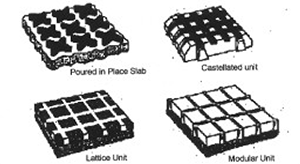
Figure 2: Various designs of porous pavements (Wong, Breen, & Lloyd, 2000)
A very important part to road design and storm water management is the composition of the road itself. There are many different approaches to building roads, some of which are shown in Figure 2, and every design has its pros and cons. Porous pavements are very popular in most normal urban landscapes which include items such as parking lots and driveways (Wong, Breen, & Lloyd, 2000). As the name suggests, this type of road design is built to provide strong structural support while allowing rain water to seep through the surface. Unfortunately, many studies have shown that this road composition has a high rate of failure when located in “high traffic volume areas” often after only a few years (Wong, Breen, & Lloyd, 2000). Whether or not Monwabisi Park would be considered a “high traffic volume area” is unclear, although “high traffic volume” seems to relate vehicle traffic as opposed to pedestrian traffic so this could be a viable solution since vehicles are scarce within the park. Either way, this downfall is something that must be taken into careful consideration when determining the road composition during the planning process.
An alternative type of road water drainage system is “swale drains”. These are large ditches alongside the road that the storm water is channeled into by the slope of the road itself. This design helps to prevent erosion and water contamination, but unfortunately it requires a large amount of space – something that is most certainly not present in Monwabisi Park although this could be something to consider along the backside of the park for water drainage provided by other methods. Buffer strips are an interesting concept that works to remove contaminants from the water so that they don’t infect the water supply and cause health issues. They have had varied success but they are also very efficient. Studies have shown that a “98% removal efficiency for sediment was found regardless of the initial sediment load and overland flow rate” (Wong, Breen, & Lloyd, 2000).
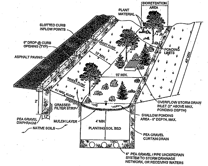
An interesting development with storm water runoff that focuses on water detention or retention has shown promising results. The main idea behind the concept is that water contaminants and pollution is separated from the road runoff using some kind of filtration system. The contaminants are then disposed of properly to prevent contamination of the underground drinking water supply. A complete diagram of how this system works is displayed in Figure 3. Systems such as this are widely used throughout the United States, Japan, Europe and Australia (Wong, Breen, & Lloyd, 2000). Before installing infiltration systems, some studies will have to be conducted to see where the primary source of water pollution originates from within Monwabisi Park, but this could be extremely valuable data to have available.

Figure 2: Visual design of an infiltration system (Wong, Breen, & Lloyd, 2000)
Lighting and Safe Nodes
There are two main types of lighting: indoor and outdoor lighting. Indoor lighting falls outside the scope of this project and will not be considered here. It may be a topic considered by the Building or Electricity teams. Outdoor lighting, though, is a critical aspect to urban planning and is typically installed along roads. Outdoor lighting typically serves several functions: traffic safety, pedestrian safety, and crime prevention (LonMark International).
In terms of traffic safety, not much is needed immediately within Monwabisi Park because few people own cars. There are also only a few roads on which cars can travel and the ones that exist are too rough for high speeds. One area to consider would be Mew Way and the other paved roads that border the park. It should be determined whether they need more lighting to increase safety or if the additional lights would not be worth the cost. Pedestrian safety is the larger factor in these areas, so areas where people cross roads should be given a higher priority than strictly vehicle areas. The people of Monwabisi Park have identified these roads as very hazardous areas, especially the road located at the back of the park (WPI, 2008). Additional lighting improves visibility for pedestrians and motorists, reducing the number of collisions and accidents (LonMark International).
Inside the park, the largest problem lighting can reduce is crime. Crime is rampant and many people will not go out at night for fear of being attacked (WPI, 2008). Adding lighting can help reduce crime in two major ways: increasing visibility and increasing pride. It has been shown through 13 case studies that adding lighting can reduce crime in an area. Interestingly, both daytime and nighttime crime is reduced. It is hypothesized that this results from a greater pride in the community, more than the added visibility (Farrington & Welsh, 2002). This is a significant principle of our work and would greatly benefit all the projects to increase the sense of pride in the community.
There are several methods to put up lighting and lots of different lighting types. In Milton Keynes, UK, the city recently put in a network of high efficiency lights that both improve lighting and reduce costs. They also adjust for the amount of daylight throughout the year, monitor themselves, and can be controlled from a central location by the city’s transportation department (LonMark International). There are large numbers of lighting solutions that exist, the most recent of which is LED lighting. Although it has been in existence for years, LEDs are only recently being used for larger tasks such as area lighting. These could save even more energy than traditional bulbs. Typical bulbs are High Pressure Sodium (HPS) lamps and Low Pressure Sodium (LPS) lamps that provide a long life but poor color rendering or Metal Halide (MH) lights that provide better color but are less efficient (Fotios & Cheal, 2007).
One can also install the lights in several ways. High street lights are typically seen around roads, but lower lights are often used in pedestrian only areas. These have the effect of making the lighting brighter, but do not cast light over as wide an area. More lights are required to cover the same area, but each light does not have to be as powerful to provide the same level of lighting. More lights also reduce shadows, but increase maintenance and vandalism. Lights can also be placed on existing buildings rather than putting up new poles specifically to hold them. A final consideration is how to power the lights. Because only half the park gets electricity, new lines would have to be strung to power them from the central grid. Other possibilities such as solar or wind power may be used instead.
Lights should be placed along travel routes to be used as efficiently as possible. As a result, they must be planned in conjunction with any plans for new roads or footpaths in addition to planning for the current situation. With changing foot traffic patterns, the lighting system may also have to change and it would be optimal to have flexible lighting that can be easily moved or adjusted for such occurrences.
In addition to improved lighting, the VPUU has proposed a design that includes the “safe nodes” previously mentioned. The VPUU describes them as “mixed use areas that provide in comparison to the rest of Khayelitsha safer residential areas, a variety of social and commercial services, recreational facilities as well as safe pedestrian movement routes” (VPUU, 2009). They will primarily be public community centers where people can congregate, have access to VPUU sponsored programs, and enjoy various other resources the centers may provide. Because the nodes will be approximately three stories tall, members of the public will be able to see a great deal of Monwabisi Park and will thus be able to spot any crimes happening in the area around the safe node. Having this “watch guard” style building will hopefully simultaneously deter crime along the roadways, as well as promote the use of the formal roadways that connect the nodes. More review by the people of the Monwabisi community is necessary in determining whether or not the “safe node” plan is desirable to residents.
Pedestrian Safety Along Mew Way
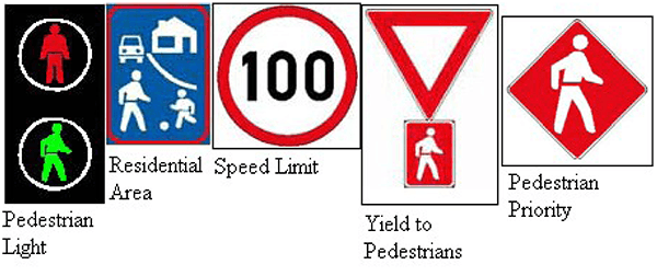
Another area of concern for residents is walking along or across Mew Way, the busy, vehicle road running along the north side of Monwabisi Park. There are numerous methods of improving the safety here. The simplest and cheapest method would be placing warning signs by the side of the road or similarly, painting them directly on the surface of the road. Some South African signs pertaining to pedestrians are shown in Figure 4 (Traffic Signs, 2005). Somewhat more expensive would be placing lights and crosswalks with a button that allows pedestrians to stop traffic and safely cross. A drawback is unnecessary disruption to the flow of traffic. A third possible solution is making a physical change in the road surface, such as a speed bump or grooved pavement. WPI students discussed several such solutions in 2008 (WPI CTPC, 2008). A final improvement can be made by better educating the residents on how to cross the road and use existing safety features. This can be done in the community education centers inside the Community Centers.

Figure 4: Pedestrian Safety Street Signs in South Africa (Traffic Signs, 2005)


