Roads Proposal
Monwabisi Park Road Proposal
Background
Presently, there are few major roads that emergency vehicles can access. This becomes a problem in the case of a fire or health emergency. Typical fire hoses run 30 meters in length and can be connected with other hoses to a total length of 90 meters. With only a few roads being fire truck accessible, we estimate that a mere 1/3 of the park can be reached by the fire hose. The other 2/3 of the park is vulnerable, which is one key reason for creating a sufficient number of roads throughout the entire park.
Less importantly, the residents of Monwabisi Park have little opportunity to own a car unless they live near a path which is wide enough to fit their vehicle. Information on car ownership varies, as according to a co-researcher living in the park, 4 out of 10 households own a car, while a slightly lower estimate was reach through field observation. However, it is evident that most households with cars are located along the main roads (Mew Way or Steve Biko), or along the wider paths throughout the park. Without adequate vehicle access to most houses, residents do not have the option to own a car and they have limited options to live near a vehicle accessible road.
Design and Layout
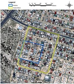
The existing layout and density of Monwabisi Park creates a unique situation when considering road design. In order to propose the most space efficient and practical road design, a comparison with the neighbouring township of Harare has been carried out. The road layout of Harare, which is structured into blocked neighbourhoods, provides vehicle access to every household. These roads meet the City of Cape Town standards of having 8 meter widths. Within one hectare, (10,000 m2), approximately 3000 m2 are used for roads. Therefore, about 30% of the land in Harare is devoted to roads alone and there are only about 50 single story housing units per hectare. However, since a hectare is only a small portion of a single block, another calculation was taken using the entire block which is approximately 37,400m2. This concluded that about 8,056 m2 was used for roads, or about 21.5%. This is a conservative figure, yet since it was concluded from a larger area of land, 21.5% was used in calculations. The hectare and block are shown in Figure 1.
The Harare road design layout is impractical for a community like Monwabisi Park where on average there are about 120 one or two-story housing units. Although there are existing foot paths currently used for automobile traffic, none of the land is used for formal, paved roads. If a road layout similar to Harare’s were built in Monwabisi Park, 21.5% of the houses would have to be removed, which is approximately 26 shacks per hectare (shown in Table 1). There are approximately 6,000 shacks throughout the entire park, which means that roads will interfere with about 1,300 shacks, causing 1,500 families to be displaced, if the Harare layout was implemented.
In order to maximize accessibility to all households while minimizing the amount of residential disturbance, a unique road layout is proposed. Currently, there are paths the residents have created over years of travel. Most of these paths are far less than the full 8 meters required by the city and are scattered, usually not following a straight line. One sensible option is to create roads conforming to most of the wider, existing paths. The park currently has little open space which can be used for relocation housing or new housing. Therefore, most roads must be smaller than the full 8 meters in order to decrease the amount of residents being displaced, since they will require new housing or relocation options. Since Monwabisi Park is a township where walking is the primary method of transportation, formal footpaths which are wide enough for emergency vehicles should be considered. These paths could range from 4.5 meters to 6 meters wide.
Respectable cities throughout the globe use different sized roads for different purposes. In some cases, a road is used mainly for pedestrian travel, yet can also accommodate a car if necessary. Figure 3 depicts a street in Galicia, Spain. This road is narrow, yet clearly wide enough to fit a vehicle in case of emergency or in order to access a particular location along the road. Pedestrians are shown utilizing the road as the residents of the park would be using the formal paths if implemented.
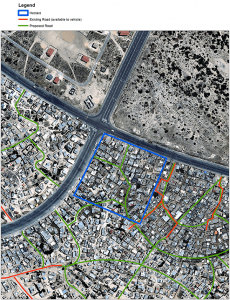
Figure 4 shows a representation of the proposed road design for all of Monwabisi Park and Table 1 compares the impact that roads of varying widths have on housing density and disrupted households. Note that these calculations are based from a single hectare in Monwabisi Park, shown in figure 2, and are approximations. Although the city standards require 8 meter wide roads, in crucial circumstances, 4.5 and 6 meter wide roads may be a better option. 8 meter roads cause a large number of people to be evicted, which creates hardship and controversy amongst residents. Another option is that the narrow 4.5 meter roads could be used exclusively for pedestrians and emergency vehicles, while the 6 meter roads are accessible to residential vehicles as well. Fire trucks are capable of accessing roads at 4.5 and 6 meter widths, so the most significant issue of emergency vehicle access would be resolved.
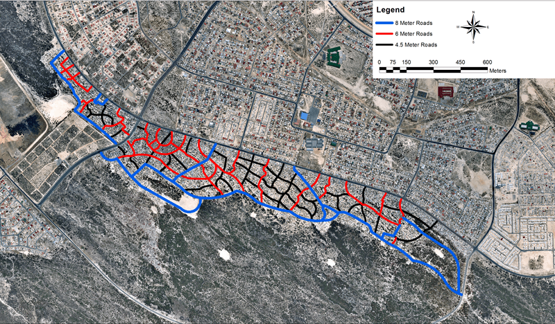
Narrow paths of 4.5 or 6 meters increase multi-use and availability, while the wider, 8 meter roads accommodate high volume traffic along with pedestrians. Figure 5 displays where different road sizes should be used. Most existing roads which are used often and are already accessible to vehicles should be built 8 meters wide. Roads which connect main roads to existing and proposed redevelopment seed/community centre areas will be trafficked often by vehicles and pedestrians, and would benefit from 8 meter wide roads. should also be 8 meters wide. However, lesser travelled roads of 4.5 meter or 6 meter widths will reduce eviction of residents. Although this layout does not give automobile access to every household, it solves the prominent issue of emergency vehicle access. Every household is less than 30 meters away from a road.
Selection Criteria for Proposed Road Layout
As previously stated, the road layout in Monwabisi Park is rather unique due to the existing scattered paths and housing layout. The placement of roads shown in Figures 4 and 5 were selected following certain criteria. Mainly, they follow the existing paths and topography of the land, yet some were added in order to create less than 30 meters of space between housing and roads. The different sized streets were placed in their designated locations for certain reasons as well. Along Mew Way there are many businesses which would benefit if there was parking nearby. Therefore, the roads that run off of Mew Way are larger, of 6 or 8 meter widths. The roads located close to proposed redevelopment seed areas with community centres are wider to accommodate parking and heavier traffic flow.
Implementation of Proposed Roads
Community centres and similar facilities are currently in the redevelopment planning process of Monwabisi Park. Once constructed, these facilities will be used often and will need easy access to them. Therefore, the implementation phases of roads should revolve around the community centres. Roads that “grow” gradually along with public and private development are less disruptive than standard “all at once” approaches, and may also allow for more sustained local road building job creation. C Section currently has a functional community centre, so constructing roads in that area first would be beneficial for the centre. In addition, there are three main roads intersecting the park; one in the back running along Wolfgat Nature Reserve, and two connecting Mew Way to the back road. These should be considered to be improved first as well.


