

Scene One: The First Pathway Experience
Backstory
Green Point Park was recently opened to the public in 2011 by the City of Cape Town. This is a good example of pathway features we would like to incorporate into our project in MGV. The park inauguration was used to celebrate the 2010 FIFA World Cup, an event which funded the project with the extra R13-billion brought in that was allocated to infrastructure.
Cast of Characters
The excursion to the park was an individual team effort so we did not meet anyone specifically. However, we did have a conversation with a security guard about the how the park was formed and discussed a little bit on how the park is run. Although we did not interact with them, there was a team of about 20 landscapers from the company Urban Landscape Solutions.
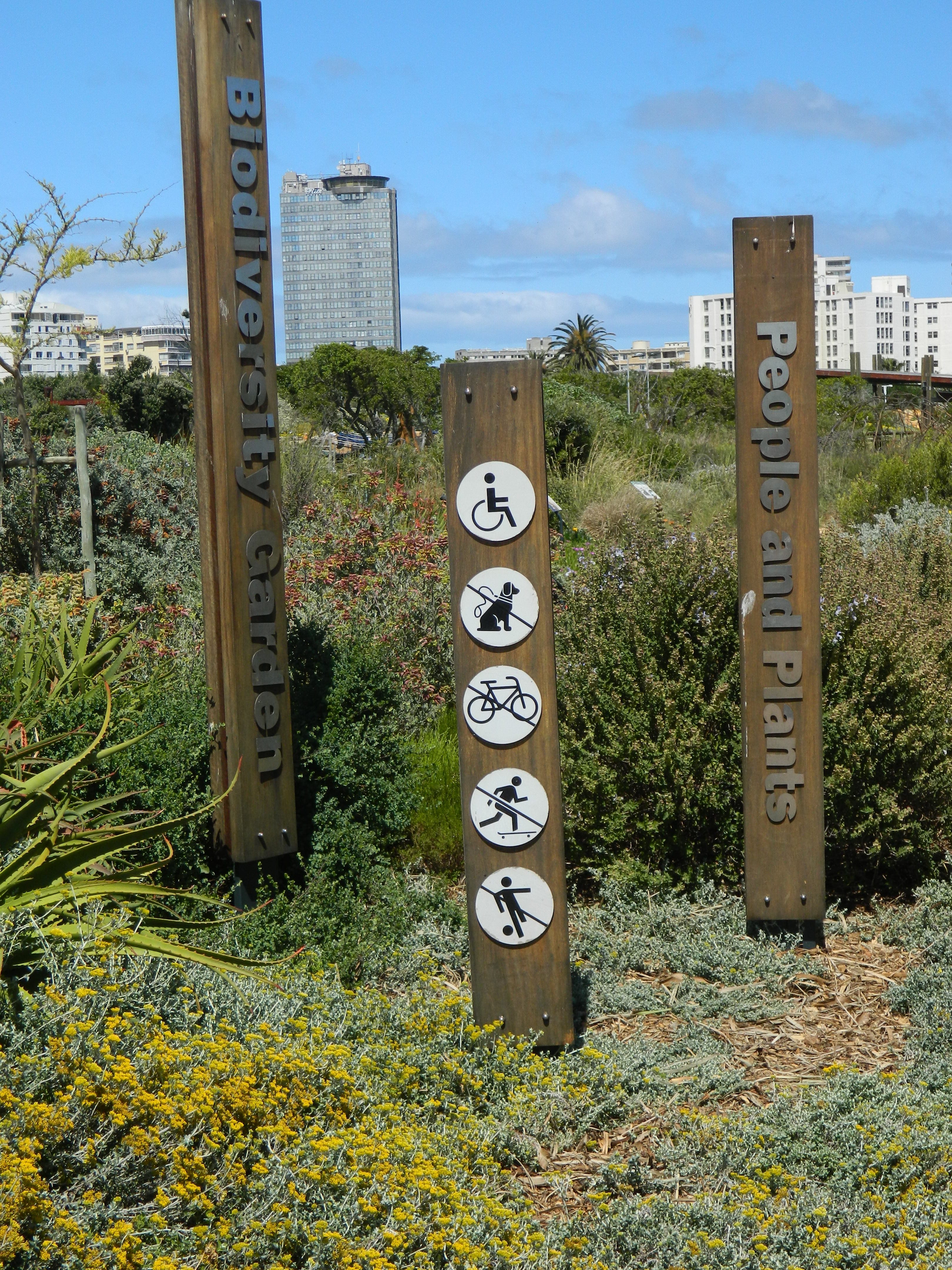
Interpretative signage in Green Point Park
Setting
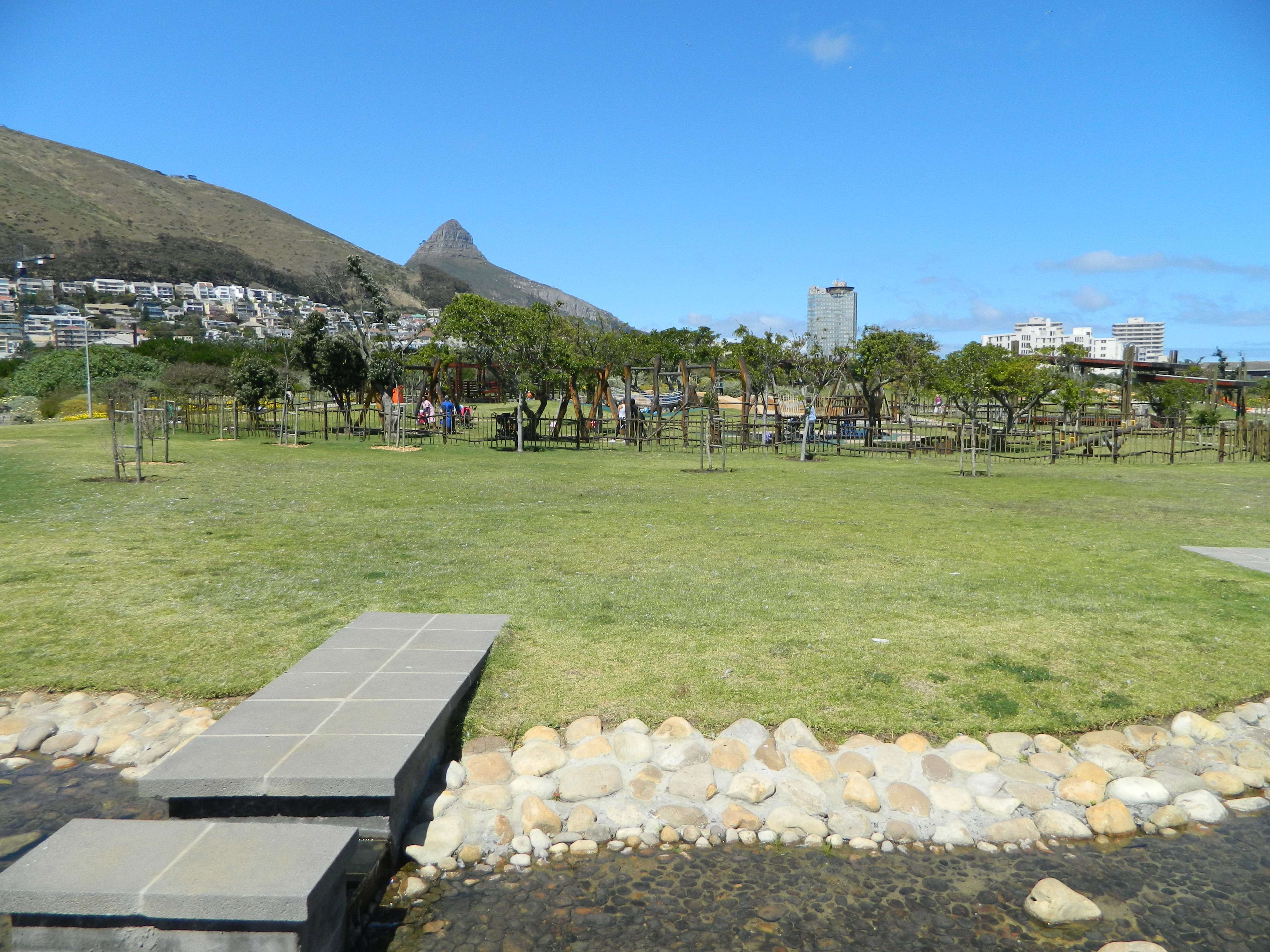
The walk to the park was almost a pathway in itself; there were two main strips, one for biking and one for walking. These paths were indicated by blue signs and metal engravings of bikes and people embedded in the pavement. Along the way, there were informative plaques that included pictures and texts on relevant history and ecology, notably ones on prisoners of war, Green Point Common, and different jogging trails. Once we got to the park, we saw that it had an open, green iron gate with a security guard in a booth to the right of the entrance. The park was extraordinarily beautiful; there were a variety of flowers that lined each side of the brick walkway in different colors like mint green and yellow. A stone water fountain with varying spout heights was located at the entrance along with assorted recycling and trash receptacles that were color coded with fun graphics. The benches at the park were a dark brown and had two armrests dividing the seating into three sections. Vertical signs for a biodiversity garden were placed at a loop pathway entrance. Vegetation was planted with descriptive signs that both gave information on the plants, information on the plant uses and posed questions to the walker to help stimulate conversation. Within the biodiversity garden were sculptures that represented the four major threats to biodiversity. The sculptures seemed to be made of metal and were somewhat cartoonish in nature since they were two dimensional yet representation three dimensional images. There were also huts made of sticks to indicate the evolution of housing around Cape Town. There were signs that helped to guide the walker through the discovery of this information. Our pathway experience concluded by walking over a bridge made from separate segments with gaps between each step. The bridge passed over a small pond that has different birds swimming and laying in the grass. One of the birds looked like pigeons and the others looked like large ducks.
Scene
Connecting
We walked about 10 minutes to Green Point Urban Park in the bright sun accompanied by a brisk wind. The whole team brought their cameras, hoping to capture some pictures that would inspire us for pathway ideas along the Black River.
Planning
We arrived at the park hoping to answer some questions:
- When was Green Point Park formed?
- What do other pathway projects look like?
- How is gardening/agriculture integrated into this park?
- What kinds of signs are used and what kind of information do they show?
- What is the physical walkway made of?
- What are some safety features?
Open park space
Action/observation
Although the pathway through the park branches in many directions, we followed the main strip and turned into the biodiversity loop. There were many flowers that lined the pathway – ones that looked like miniature sunflowers, small herb plants that were mint green, orange and red striped flowers and green, leafy plants. The pathway was made with an orange brick and dark brown benches were placed on either side of the pathway and in the middle of the pathway. There were signs that had maps of the park, information about the park, recycling information and historical information. The large signs had three languages while smaller signs were solely in English. The biodiversity section had small signs next to each plant which described the plant and its uses. There were also hut frames made from long twigs to represent different housings which included one that looked like an igloo and other variations. We then crossed a bridge that had gaps between each step, and while there was signage warning users of this feature, there was nothing to explain the reasoning. The pond under the bridge hosted much wildlife such as water lilies, pigeons and native ducks.
On the way out of the park, we decided to ask the front security guard a couple questions we had after walking around. Although he was unsure of when the park was made, he knew that the owner’s name was Richard and said that he was easy to get a hold of. He also said that we could possibly get the plans for the park as well. There was an empty sand pit that lined the left side of the pathway and was gated away from the rest of the park. The guard said that they keep that land aside for developments that may happen in the future. We also saw about 20 men in blue uniforms working for Urban Landscape Solutions. The guard said that they are there five days a week working on the landscaping which changes with the seasons.
Reflection and learning
The park was originally found by a few group members who arrived to Cape Town early and explored the nearby area. Three of us did not know what to expect from this park but were pleasantly surprised to find such a nice, developed area. We thought this would be a great example of what we want to do with our project since it had a lot of the elements that we discussed in our prep term such as gardening, safety features and recreational space.
Another surprising part of the day was meeting the security guard. It started with a tree that our team was trying to climb but was struggling to actually get up on. The security guard started to approach and we thought he was going to yell at us. Instead, he offered to lift us up on his shoulder so we could climb up. At first we thought he was kidding, but it soon became apparent he was serious and just being friendly. This really shocked us because we are not used to such an instant and high level of interaction with someone who is part of the community. This gave us the courage to initiate a conversation with him at the end of our walk and really get some useful information. This was a really useful connection to make because it really made us feel more comfortable when approaching other people that we may not know so well.
Notes for the future scenes:
We have now gained a basis for another contact in Cape Town besides our sponsors and co-researchers. Richard, the designer of Green Point Park, is a potentially useful resource that can guide us in our pathway planning. We want to find his information and potentially set up an interview.
Now that we have seen an example of a recently renovated pathway, we can start to imagine how different aspects can fit into MGV. What does the MGV community like about the pathway? (we have many pictures to use for visual aid)
Something to consider is how this endeavor really affects future scenes: How can we use this park as an example?